Anti-Clockwise Denis Rankin Round
39 mountain summits
Solo. Unsupported. Map and Compass.
20 hours 48 minutes
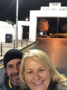
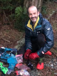
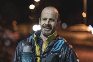
Although myself and Hazel were staying in the Avoca hotel, beside Donard car park, getting to the start at the White Arch proved a bit tricky when the time came. It was after 1am, and people were spilling out of the pubs at the end of the last Saturday night before Christmas. When we opened the hotel door to leave, a young guy, very much worse for wear, tottered in, clueless of where he was, and we had to turn him around and head him down the street. As we walked toward the car park with ten minutes to spare, we came upon a number of lads in doorways, at least one of them passed out, and there were boy racers flying up and down the car park. We decided to go back and wait in the doorway of the hotel, and with 2 minutes to go we flew around to the arch. On our way we passed two lads, one shouting incredulously “are you going for a run?” When I replied “yes”, he laughed and shouted “my mate just ran into a lamp post!” Hastily we took a picture, counted down and then ran in the opposite direction.
As it was quite warm I had my jacket and top zipped down, no hat, and just liner gloves on and I took it easy going up though the forest, only jogging when I hit a flat spot. When I came out at the Ice House it was a bit misty, and it came to mind that during good weather there’s nearly always a smell of campfire smoke here. Tonight though, the air was fresh with just a light breeze. Keeping an easy but steady pace along the Glen River Trail, I made it across the river and up the steps to the saddle, with the wind increasing the higher I got. About halfway between the saddle and Commedagh summit I passed into cloud, and visibility dropped to less than 2 metres. As I climbed I fully wrapped up against the cold wind and once I reached the top I could only tentatively work my way from the wall to the cairn through a thick whiteout, with the headlamp beam bouncing back off the mist in front. I felt good and thought that I’d have a decent split for the first climb, but was very surprised to see it was slower than a recent morning outing, when I’d power walked it in sleet and snow. I touched the cairn, set a bearing for the southern rim of the corrie and headed off. However, due to the poor visibility, after about 200m I decided to err on the side of caution, and adjusted a few degrees south so as to guarantee I’d pick up the Mourne Wall rather than the cliffs.
Visibility remained minimal across Corragh and Slievenaglogh, and whilst it didn’t cause any navigation problems, it was a bit frustrating not being able to pick good lines where there were multiple trail options, or boulders and slabs worth avoiding. Going across Hare’s Gap the cloud thinned somewhat, but once I started up Bearnagh, it thickened quickly, and combined with the darkness it made it difficult to gauge my progress towards the top, with me initially mistaking the North Tor for the summit, and having to clamber awkwardly around it before making it to the real summit. The forecast was for minus 6 degrees at night, and at this height the cold wind was strong and I donned a full balaclava as well as buff, hat and a second set of gloves, but once I got down towards the saddle I was sweating again and pulling them off. This sequence was repeated throughout the night section at every summit/saddle due to the differences in weather conditions.
As I worked my way over Meelmore, Meelbeg and Slieve Loughshannagh I found I wasn’t feeling as good as I should have been and was looking forward to my break once I made it to Spelga. I took the high trail and stoney way to Ott, then a direct bearing to Muck. I like the direct line between these two but the descent from Ott presented a few tricky incidents, where the poor visibility prevented me seeing rock shelf’s on the grassy slope in good time, and I had to stop dead and walk down and around them a few times. I was pleased though when I saw the fence and realised that even in the dark white out I’d arrived at the correct fencepost by compass alone. Once I crossed the road I started plodding up Muck and that’s when the temperature really dropped, the wind coming across the reservoir making my lips feel like ice. From Muck I again took a bearing, directly to Spaltha summit and once again, on the climb the temperature dropped significantly. From there I set my compass for the toilet block 1.5km away and headed diagonally down the flank, and was delighted when, with about 20m visibility I arrived bang on target at the fence corner behind the block. I went into the doorway, took off my 4.5 kilo pack and had some rashers and pizza, as well as a bar of chocolate, but didn’t hang around long before making my way across the dam and on up Miskan, and across to Cock North East without incident. However, on the descent to the saddle with Cock South West, in the mist, I picked up a small side trail by mistake and veered south, below the saddle. Once I realised I was off course I made my way back up to the trail and contoured around the S.E. summit. I had identified a couple of direction hints in the distance on recces, based on the silhouettes of the summits on the opposite side of Rocky River Valley. Unfortunately, with no visibility I had to take a compass bearing and head downwards, filling my bottle before picking up Hen track and making my way to the bridge. From there it was a straightforward trail run to Rocky, and up/around Tornamrock towards Pierces Castle. This section of trail is a little over 1km long and well defined, but in the darkness and with zero visibility, I meandered onto small side trails a couple of times. The biggest surprise though was when a breath of wind briefly cleared the mist and I saw the Castle Tors 3 metres away, on my left. I was almost within touching distance, but was running past them. I walked back a bit, climbed up a cleft and summited, before getting back on the trail and continuing on towards Tievedockaragh. This whole area felt strange in the dark and mist, and I had to reassure myself I was following the correct access trail until I reached its T-junction turn. It was still pretty cold too, and as I ran I did arm exercises to get some heat flowing to my fingertips.
I left Tievedockaragh to a compass bearing, but it’s actually quite difficult to run diagonally downhill, over very rough ground which is covered with thick vegetation, and keep an accurate heading. Rather than constantly stopping to let the compass needle settle, you keep going, optimistically thinking you’re going grand. But with absolutely no visual cues it’s almost impossible to stay accurate to your desired bearing. I veered a little to the East, which put me onto a faint trail that led to the forest entrance, and onto sloppy forest trails. I expected the forest to be mist free, but there was no let up, and combined with the twists and turns along the slippery ground, it was hard to stay upright and move at any decent pace towards the Bog.
In Kilbroney Red Bog there’s a plaque on the bench overlooking the lake. The inscription is in Irish and it roughly translates to “sit here for a while, be quiet, and peace of mind will come”. I do this each time I’m passing. Today when I reached the bench it was the tail end of nautical twilight, and there was just enough light to make out the lake in front of me, so I removed my pack and sat down for a few minutes, in one of the most tranquil spots imaginable. Then it was back to the sloppy, twisting bike trails to Slievemeel and from there, a compass bearing to the darkness of Rostrevor forest. Although it was civil at this point, there was still mist in the forest and except that it was forestry road, I would have still needed a headlamp. At one point there was regular movement at ground level, slightly in front of me. I assume it was a small bird flitting slightly ahead of me repeatedly, as they do sometimes on the fringes of forests or on meadow trails, but I couldn’t say for certain.
I hadn’t been feeling 100% for about an hour by now, so before taking on the slog up Crenville I took another 5 minute break and then summited without any problems. Leaving the summit was tricky though. I use the layout of a series of trees to guide me in the right direction, but even though it was daylight now, in the whiteout of mist I couldn’t make out the exact trees until I was right upon them, which slowed me a bit. It was the same for the climb to Slievemartin, thick mist obscuring every visible feature and way mark. To alleviate the problem I climbed a bit to the West so as to pick up the fence as a handrail to the summit.
On the way across to Slievemeen I passed 3 dog walkers, as the wind picked up a bit and it started to rain. I’d now been up for 24 hours and was feeling tired, so I passed over the summit, lay down on my side in the heather, set my timer for ten minutes and went to sleep in the rain and wind. Pol O’Murchu was mountain biking locally and keeping an eye out for me, but our paths never crossed, possibly because I was asleep at the time! When I woke I had a bite to eat and started for the long trek to Finlieve, feeling that with the sleep and the daylight ahead, I would feel fresher shortly. Even when recceing for a mid-winter Round, taking bearings, noting waymarks and landmarks, you never really assume you’ll have absolutely no visual cues. And unless you’ve navigated in those conditions, it’s hard to understand how easy it is to go a couple of degrees off course from a desired bearing. As if to prove this, I went off course on my way to the forest at Watergap River, not seeing the forest until I was a mere 20 metres from the treeline, and realising I was 250 metres to the West of the entrance. Thankfully, once in the forest it was good running all the way to Fallow Stream, and then a compass bearing for the almost 2km climb up Finlieve.
From Finlieve to Shanlieve is about 2.5km of the trickiest navigation of the Round, the optimum route snaking on and off the watershed of a peat hag and blanket bog covered ridgeline. Early on in my preparations I’d considered this as a night section, but after a few recces I decided that the level of accuracy needed was too complicated, and too easy to mess up, so I switched it to a day section. However, in the thick mist those night recces paid off. I used my compass, in conjunction with detailed notes on my map, to correctly navigate from waymark to waymark, all the way to Shanlieve in a decent time. This little achievement put me in great form for the run along the Mourne Wall to Eagle and Windy Gap. From there I contoured around Slievemoughan for a set amount of minutes, then used a compass bearing to the start of the ascent of Wee Slievemoughan, and finally followed bog cuts and trails to the summit. One small issue occurred during the hike to a bearing. I often talk, laugh or sing out loud, and during the hike over rough ground, I was talking to myself about the time around Slievemartin. I was saying “horrible, horrible, horrible”, and on the third “horrible” my right leg went down a heather covered rock hole, to the hip joint, jolting a disc in my back that I regularly slip. I thought that would lead to a full hernia but thankfully the pain eased away quite quickly.
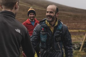
Wee to Moughan can trick you. I’ve dropped too low off the North East of the saddle a couple of times in bad weather. Unfortunately, with this in mind I overcompensated, and pulled my line a bit too far South West before realising the vegetation underfoot was wrong. I quickly adjusted my direction, and climbed steeply to the summit. I was feeling good at this stage, having fully come round from the little blip on Slievemeen, and loved the run across to Pigeon Rock and down to my first meeting of the day, at Deer’s Meadow. The descent was a mire of mud and grass, but it was great fun. Once I got below cloud I could see Hazel’s car and gave her a big shout, with her returning it (like Adrienne and Rocky in the film-big saps!). I was delighted to see her, and it really gave me a boost. As I climbed over the stile a car pulled up and a group of runners got out. Paddy O’Laoghaire, Gavin Byrne and Dylan Ladds had a showing of their Wicklow Round film “Coming home” scheduled for Tollymore that evening, and had come out as support when they heard of my attempt. Hazel also told me she had been talking to Niall Gibney for a while. Niall had run the Round two weeks previously, and had come out with his son to run some of it with me. Unfortunately, my nap, and the poor weather conditions had meant I was too late to meet him. I had a good break here, with plenty of chats and laughs, then filled my bottle in the gully at the side of the road before making for Slieve Muck. Fully conscious of the eyes behind me, I pushed hard, never stopping til I reached the summit trig pillar.
Sometimes over long periods of running you fall into a comfortable, safe pace and forget to push yourself a bit. Feeling good after Deer’s Meadow, confident that I would have no problem completing the Round, and having raised my heart rate without any tiring effect, gave me another boost in motivation, and I picked up my overall pace a bit from here on. Just after leaving the summit I passed a couple walking their dog, then remembered to check my phone battery, and saw that the power pack wasn’t connected properly, so I had to reconnect it. A simple task like this can be ever so slow and frustrating when you’re wearing two pairs of wet gloves….taking the phone and power pack out of the waterproof pouch, re-connecting cables and re-sealing it all takes minutes instead of seconds.
Once fully packed up again I had a good run over Carn and onto Loughshannagh trail, which I followed about halfway around, before taking a bearing across country to pick up the trod along Ben Crom River. Two walkers were 10 metres away, approaching me, as I left the trail, and I’m sure they thought it looked odd, a runner just jumping off the trail and running across rough, bog slog ground towards nothing obvious, as if deliberately avoiding them! I summited Ben Crom and Doan handily, and enjoyed a good run along the technical Bann’s Road, and a straightforward climb up Slievenaglogh.
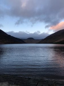
From there I followed the wall and deer trails down to the dam at Silent Valley, seeing Hazel and shouting her name again, before she could see me. I was really relaxed and in great form now, feeling 100% as we shared a stroll across the dam and admired the glint of orange in the sky towards Kilkeel, as it was nearing sunset. This was the one and only time that I saw the sky during the entire Round. We then stopped at the trail head behind the café and I sat on the ground to have some food while we chatted. Myself and Hazel both get a kick from little things we notice when we’re outdoors, and while we were chatting, a little Christmas robin stayed beside me on the ground, hopping around, hoping for a bit of food. Then it was time to pack up again and head off on the last leg, starting with Wee Binnian. Daylight faded away on this climb, and I put on my head torch as I passed over Moolieve. After summiting Wee, I descended to the saddle and started the very tough climb to Binnian. I took it slow and steady, planning to climb high along the wall, contour a bit, and then climb/contour by various trods, to the col between the summit tors. However, with darkness and mist once again, having left the wall I managed to contour at one height for too long, missing a faint but crucial fork in the trail which would have brought me to the col. Once aware of this I turned and climbed straight upwards through the boulders and vegetation, knowing I’d either hit a tor or the col. As it turned out I arrived at the sheer granite face of a tor. But which one? Was I north of the col or south of the col? Feeling that I’d contoured too long, and passed the col, I turned right and marched up under the tor face, and got to the col, and up onto the top of the tors.
Before I’d left Dublin, my two sons, Ethan and Kaelem, had written a note each, for me to read when I hit my toughest point of the Round. I didn’t know when that would be, and was tempted to read them at Slievemeen, but figured that worse could still come. Although I was feeling strong and positive when I mis-navigated to the col, on the direct climb up I decided to stop on Binnian, and read the notes. It was pitch black, with a hard wind blowing a thick mist around, so I turned into the lee of some rocks at the summit and took out the notes. Without getting into the content, its nicely surprising how tuned into you your children can be, and after reading them, I packed them away with pride. I put my pack back on, cinched everything up tight and turned to leave the summit. However, as is so easily done after you stop in those conditions, I started out incorrectly. I’d turned off my running line into shelter to read the notes, then started to run as if I’d just stopped on my trail. Within a few strides I was looking directly down about 20m of cliff, over the side of the tor I’d come up past. I immediately realised the error I’d made, got back on track and had a great run along the tricky, rock strewn trails to North Tor.
This was where things started to transform for me. From here on, the more technical the trails got, the more wild the weather, the more enjoyable, confident, strong and fun my running became. Although there’s a myriad of off trails and possibilities for going off track, every step just felt right, and I barely felt the need to look down. Once I was down at the saddle before Lamagan, I decided to keep calm, let myself find a good climbing pace through the boulder scree, and strictly follow a compass bearing to the summit. Just using the compass to navigate this climb was very satisfying, when, after a half hour climbing to a bearing, repeatedly correcting my line after going around obstacles, I summited perfectly. I then enjoyed more good running towards Cove, taking the correct lines at all the sneaky, indistinct trail forks along the way. It was at this summit that a rather unpleasant accident occurred. I turned my back to the wind to have a wee break, but with the winds squalling in all directions, I managed to wash my face! I had a laugh at this mishap, then weaved my way around to the saddle river. This was a tricky descent, having to curve and drop through scree and rock in the combination of mist and darkness, and requiring a good deal of concentration so as to not lose direction onto rough mountainside. I succeeded in making it to the river crossing at the right spot, had a drink, filled my bottle and made for Beg.
I concentrated hard on this climb. In the poor visibility its easy get side tracked northwards, into peat hag dead ends. The concentration paid off, and from there I had a sublime run along the technical Brandy Pad. This was one of the most enjoyable parts of my Round, I felt on a high running over and around the rocks, feeling stronger and faster the further I ran. After spending 19 and a half hours and 75km ascending and descending the steep rough ground of 36 mountains, and concentrating on navigating, I got into a great rhythm as I told myself to go faster. Normally as soon as you tell yourself you’re in a zone, nemesis catches up with your hubris and you trip, but it didn’t happen this time. I just stayed in the zone, loving the running, and the confidence and strength I was feeling, getting to Rocky 10 minutes ahead of my target split.
Coming off Rocky in darkness needs some concentration, as the trail head from the summit is not obvious, and lower down, there are possible side trails as you get near the Mourne Wall, so I paid attention and got to the stile without a hiccup. There’s a huge difference between what’s required from a daylight fell run and a darkness fell run. The level of detail needed from recces is huge. Trails that you could never leave in daylight can become a criss cross of tiny optional trails, that can puzzle you when you have nothing else to give you a clue. From the stile I headed in the usual direction to cross Spence’s River, but when I reached it, it was dry. I’d never seen it like that before, but continued until I noticed that the ground wasn’t rising on the other side as it should have been. Figuring there must be an old stream bed that I’d never seen before, I adjusted my line and got onto the correct trail and reached the fording point of the river. I then ran along the old stone workers track to a set point, took a bearing up through thick vegetation, past a couple of waymarks, and picked up a sheep trail to the ridge trail, which I followed to Chimney summit.
That just left Donard, a long tough climb, which I was looking forward to. Once I successfully got across the Bog of Donard and to the Mourne Wall, I had a couple of sweets and a bar of chocolate as I started the climb. I decided that I wouldn’t stop at all on the climb, letting my legs burn and my breathing get hard, but my energy not flagging. With about a third of the climb behind me I started to verbally push myself, out loud. It started gradually, but before long I was screaming out loud like Davy Fitzgerald on the sidelines of a GAA final. I’d never done that before, and it felt great. I was shouting at the top of my voice, how the lads had faith in my ability, how Hazel was waiting for me, how much I’d trained, lots of great thoughts. I kept pushing myself as my legs burned, shouting that there was only 10 minutes climb left, only another 5 minutes, that the tower would be in sight in 3 minutes. I just kept reducing the amount of time I figured was left to push hard, giving myself a reducing amount of work to face. And then on cue, through the mist and wind, I could see the Water Tower just up ahead. It was howling a gale at this height, with thick mist swirling around, so I stopped there, under the cover of the tower, to get ready for the descent, changing the battery in my headlamp, having a drink and eating a sweet. I texted Hazel that I was about to start the descent, and that I would see her in 42 minutes. Once I was tightly wrapped up with balaclava, hat and buff, I left the protection of the wall. It was very difficult to even trot in a straight line towards the second cairn, having to lean in to the strong crosswinds coming at me sideways. Added to this, I was trying to compass navigate through the mist, across the summit plateau which was just an expanse of white and shadow. I was very worried I wasn’t going to hit the cairn, but persevered, and after what felt like too long, it suddenly materialised out of the dark mist. From here, it’s a steep descent through a maze of boulder fields, but I was still feeling great, so once I had this waymark, I confidently set a compass bearing, and descended to my next waymark. At this point I felt that my navigation couldn’t go wrong, even though I had no visibility in mist, strong winds and darkness. Without further checking my compass, I changed direction at each waymark by gut feel and didn’t break my stride, almost recklessly jumping amongst the boulders. By a combination of hard worked recces, and a bit of luck, I hit the trailhead bang on target, and bounced in long strides all the way to the Black Stairs. I clambered down the steep rock shelfs and ran to the Ice House with a smile on my face, as the mist finally cleared. Once across the Glen River, I stopped, took off all my cold weather gear, opened up jacket and top zips, dumped my water, tightened up my pack, and legged it towards Donard Park.
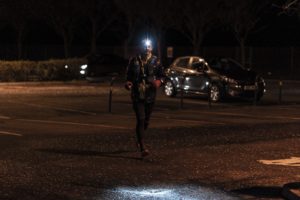
It was an easy 1.5km along the Glen River Trail to the car park, and once I came out of the tree line I could make out Hazel standing at the white arch and gave her a big callout, to which she happily replied, as I ran the final 100 metres. 42 minutes after my text, I touched the arch and gave her a big hug as her phone rang, Rowan McMahon from Primal Tracking, to tell me to turn my trackers off. I hadn’t paid enough attention to his initial instructions though, and pushed the SOS button instead of the off button, on both trackers! Fair play to Simon Kelly in Waterville who was keeping a safety eye on the challenge, he was on the ball and rang Hazel immediately to make sure I was OK.
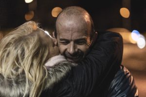
It’s no understatement to say that I was euphoric at this stage, the last 15km having been the most enjoyable not just of the day, but of any run I’d had in a long time. We had just shared an amazing experience and Hazel was on cloud 9 as much as I was. Paddy and Dylan were at the finish too, having treated Hazel to tea and biscuits during the film screening and adding to her overall experience of the day. We had driven up on our own, planned to have a low key push around the Mournes for the day, possibly with me grinding the challenge out from start to finish. However, as well as having Simon’s reassuring phone presence, Hazel had met, and been supported by many strangers, making her feel like part of a bigger, Round focused family. I’d a rough beginning, a lot of minor mishaps, but from when I met Hazel, and with the support of the others, the day became something else. Neither of us over state things, but as we got ready and drove back to Dublin, and for days after we were both shell shocked in the most satisfying way. We both kept exclaiming “wow”, “how did that happen”, “that was amazing”. Preparing for such a challenge can put strain on relationships because of the focus required, and particularly with a solo, mid-winter, unsupported attempt, trying to navigate without electronics. The level of preparation needed is enormous, and the distraction from daily life can be too much at times. But we were both blown away with the almost spiritual, uplifting bond we shared during and after the Round. I doubt if I’ll ever have words to express it fully.
I’m a bit of a loner, in the 5 years I’ve been running in the mountains, I’ve only run with someone else 11 times. Spending time alone in the open mountains is at the heart of my running, the wildlife, the vegetation, the landscape, the archaeology, the geology, the local history and of course, the weather. I don’t talk about running, most people who I meet don’t know I run much, and I’ve only 1 plaque in my house. But Hazel gets it. Thank you.